


If you’ve been monitoring the snowfall in the Alps this week, you’ll know that the narrative of the 2025/2026 season has been not just a snowy one, but potentially one for the record books. While the early winter season started with relatively low snow cover, followed by the Pyrenees taking an unexpected lead, the Alps have spent the last 48 hours making a deafening statement.
But… Is there such a thing as too much snow?
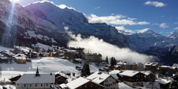
Well, as of February 12, 2026, we are in the middle of an Alpine snowfall of historic proportions. If you’re currently in the Savoie, Isere, Tarentaise or the Aosta Valley, you’ll know that we’re seeing what can only be described as an EPIC snow dump – with around 60cms in Les Arcs within the past 24 hours.

The French Alps: Red alert conditions
In France, the situation has moved beyond powder day territory and into the realm of extreme weather management. As of this morning, parts of the Savoie and the Mont Blanc massif are under a rare Level 5/5 Avalanche Danger warning. A level 5 avalanche rating is rare, but has happened previously in April 2025 and at several other points in the past 10 years.
The numbers coming out of the French giants are, quite frankly, staggering. In the last 48 hours, forecasters have seen between 70cm and 100cm of fresh accumulation above 2,200 meters. Locally, in the Oisans and around the Mont Blanc massif, totals have nudged toward the 1.5-meter mark.
This has had a massive impact on resort operations:
- Chamonix: The valley is effectively on lockdown. High-altitude sectors including Brévent, Flégère, and Les Grands Montets were closed today as patrol teams struggle with visibility and extreme slide risks.
- The Tarentaise: Tignes and Val d’Isère are reporting some of the heaviest snow of the decade. While the skiing is world-class, the “pisteurs” are working double shifts to secure the slopes.
- Current Depths: Flaine is sitting on a mighty 250cm upper base, while Les Deux Alpes is holding 235cm.
If you are heading to the French Alps this weekend, you might find plenty of snow, but less terrain available to explore. If you can, stick to the lower, tree-lined runs like those in Les Houches or Morzine, and do not even think about the backcountry until the pack settles.

Italy: Olympic standard snow
Cross the border into Italy’s Valle d’Aosta, and the story is just as intense – although the biggest impact remains around the French border. Courmayeur has become the epicentre of this storm cycle, reporting a full 100cm (one meter) of snow in just 48 hours!
The Aosta Valley is currently a deep mid-winter fortress. Cervinia is reporting an upper base of 155cm, and the local forecast for the next seven days suggests another 76cm is on the way. However, the Italian authorities have issued a Level 4 (High) avalanche danger across the region. Sadly, this storm has already shown its teeth, with multiple fatalities reported over the last few days in the backcountry of Lombardy and Trentino.
For those of you paying attention to the Winter Olympics, you’ll have noticed that lowered visibility and snowfall over the past couple of days. Cortina isn’t seeing quite the excessive snowfall as the rest of the Western Alps, but the forecast does look like there will be plenty of fresh snow in the coming week.
For those looking for the best snow in Europe this season, the Dolomiti Superski area is also seeing a massive refresh, with nearly a metre forecast over the coming week. The contrast between the sunny Italians and this current blizzard-bound reality couldn’t be sharper.
Switzerland and Austria: Cold front but less snow
While France and Italy take the brunt of the moisture, Switzerland and Austria are actually looking enviously to the south – although the south of Switzerland is still seeing
In the Swiss Alps, a large rock avalanche near the Italian border has highlighted how much pressure these mountains are under. The forecast for the next 14 days in the Swiss heartlands—Verbier, Zermatt, and St. Moritz—shows a “conveyor belt” of snow showers. But the real story here is the cold. We are looking at night-time lows dropping as far as -19°C in the higher Swiss valleys by February 22.
Austria is currently slightly milder but catching the tail end of the western fronts. St. Anton and Ischgl are seeing consistent refreshes of 10–20cm, keeping the pistes in pristine condition. Yes, this isn’t on the epic end of the Alpine snow conditions, but at least you’ll be able to ride pretty much all of the ski areas without worrying about avalanches – for now.
In fact, Austrian forecast suggests a dip in temperatures toward the end of next week, which should dry out the snowpack and provide that hero powder the Arlberg is famous for.
What is the forecast for the rest of 2026 winter season?
The current storm cycle looks set to continue into the coming weeks, just in time for the February holiday season. One thing is for certain and that is that it’s going to be very cold – so if you’re heading to the Alps in February pack for freezing daytime temperatures, not bluebird days.
In fact, even if you’ve taken a bet on a lower altitude French, Italian or Southern Swiss ski resort this Feb, you might just have lucked out. With Argentière and Megève forecast to receive over 130cm in the next seven days alone, the snow volume is no longer the issue; the challenge is safety and visibility. And if you’re planning any kind of off-piste or backcountry, a guide and adequate equipment is a necessity.
Right now, the Best Snow in Europe crown is currently a tie between the French Hautes-Pyrénées (for sheer depth) and the Aosta Valley/Savoie (for recent delivery). Pack your low-light lenses, your warmest base layers, and a healthy dose of patience – the Alps and the Pyrenees are both currently in full winter mode.


